
Three roads on Hawaii’s Big Island lead from Hilo to Kona. The north road that curves around Mauna Kea can be cramped with traffic delays (98 miles). The south road twists through a volcanic haze until you crest Mauna Loa (125 miles). Many locals skip the traffic and the avoid vog by taking Hawaii Route 200: Saddle Road (85 miles).
Starting from Bayfront in Hilo, wind up Wainuenue and Kaumana Drive. Ua Nahele at mile marker 8 is the last cluster of houses before you enter the wilderness.


Saddle Road grew from a primitive path. Ancient Hawaiians walked single file on a narrow trail through cloud forests and barren lava fields. Although much of Saddle Road is streamlined for speed, the Bad Turn at Mile Marker 11 is a remnant of the ancient path.

Cyclists
Sally and Michael take a break at mile marker 22 before climbing the
mountain. Hula Dancers come to the rain belt on this
stretch of the highway to pick liko, the budding red leaves of the ‘ohia
trees to make their haku lei. I stop to pick tart ‘ohelo berries
by the old road.

 From
hunters to astrophysicists, mile 28 marks a hub of activity. Mauna Kea
summit (13,800 feet) hosts 12 telescopes from 11 countries. The
Onizuka Visitor Information Center (9,200 feet) conduct stargazing
activities nightly. Below the visitor center Mana Road provides a
deeply rutted 4 wheel drive adventure for hunters, nature lovers, and
extreme cyclists.
From
hunters to astrophysicists, mile 28 marks a hub of activity. Mauna Kea
summit (13,800 feet) hosts 12 telescopes from 11 countries. The
Onizuka Visitor Information Center (9,200 feet) conduct stargazing
activities nightly. Below the visitor center Mana Road provides a
deeply rutted 4 wheel drive adventure for hunters, nature lovers, and
extreme cyclists. Hitchhikers Sean and Yogi have made it to Mauna Kea Summit Road. They plan to camp amongst the dells of the summit, to play digeridoo, and commune with nature.
South
side of the Humu’ula Saddle, lie the remnants of the Hilo-Kona Road. Bedded on
cinder and gouged with potholes appears undesirable for driving, but
less than a hundred yards off Highway 200, the old road transforms into
a smooth lane of fresh dark tar that travels 17 miles to Mauna Loa
Observatory.
 In
1849, Governor Gerald P. Judd used prison labor to construct a
Hilo-Kona road, but work stopped when lava from a Mauna Loa eruption
flowed across the proposed path. In 1943, after the attack on Pearl
Harbor, the Army Corps of Engineers raised a gravel path for military
vehicles to cross the island. The road was not intended for public use
and received minimal maintenance until 1992. Twenty years ago, the road
was a narrow maze of spot patches. Rental cars were not allowed to
travel Saddle Road.
In
1849, Governor Gerald P. Judd used prison labor to construct a
Hilo-Kona road, but work stopped when lava from a Mauna Loa eruption
flowed across the proposed path. In 1943, after the attack on Pearl
Harbor, the Army Corps of Engineers raised a gravel path for military
vehicles to cross the island. The road was not intended for public use
and received minimal maintenance until 1992. Twenty years ago, the road
was a narrow maze of spot patches. Rental cars were not allowed to
travel Saddle Road.
A
mile above sea level, in the plateau of the Humu’ula Saddle, vehicles
seem to soar over gentle curves. You feel like you are flying, which
can be a problem because the speed limit is 55. Watch for a change in
speed limit just before Mauna Kea State Park. Between the park and
Pohakuloa Military Compound. The posted limit is 45 which is strictly
enforced.
 At mile 34, Mauna Kea State Park has the only public facilities on Route
200. If you have to pee do it here. Be prepared to put on a sweater
before you get out of the car because a biting wind blasts through this
part of the saddle. The restrooms are clean and the toilets flushable,
but in lieu of soap and a handwashing sink, a dispenser of
antibacterial gel is attached to door. On weekends, you can rent one of
the cabins from Hawaii State Parks.
At mile 34, Mauna Kea State Park has the only public facilities on Route
200. If you have to pee do it here. Be prepared to put on a sweater
before you get out of the car because a biting wind blasts through this
part of the saddle. The restrooms are clean and the toilets flushable,
but in lieu of soap and a handwashing sink, a dispenser of
antibacterial gel is attached to door. On weekends, you can rent one of
the cabins from Hawaii State Parks. Keep
your speed down as you head West toward Pohakuloa Military Camp.
Quanset huts mark the entrance to military housing on the South of the
road. When you pass the three large water towers on the North side, you
are out of the 45 mph speed zone and can gas it back to 55.
Keep
your speed down as you head West toward Pohakuloa Military Camp.
Quanset huts mark the entrance to military housing on the South of the
road. When you pass the three large water towers on the North side, you
are out of the 45 mph speed zone and can gas it back to 55.  About
a mile beyond Pohakuloa, a chronic dust bowl settles at the base of a
steep grade that climbs to the peak of the saddle. The road climbs in a straight line to the highest point of the saddle.
From here to Mamalahoa Highway one lane bridges traverse the watershed. Downhill
traffic has Right of Way, so if you are heading uphill, yield to
oncoming traffic.
About
a mile beyond Pohakuloa, a chronic dust bowl settles at the base of a
steep grade that climbs to the peak of the saddle. The road climbs in a straight line to the highest point of the saddle.
From here to Mamalahoa Highway one lane bridges traverse the watershed. Downhill
traffic has Right of Way, so if you are heading uphill, yield to
oncoming traffic. 
The
top of this grade is watershed elevation, the highest point of Saddle
Road. Simple dirt parking pull-outs serve as scenic points near mile 44,
Kilohana Girl Scout camp. Photographers will want a wide angle lens or
panoramic setting for sweeping views of Mauna Loa, Mauna Kea, and
Hualalai.

The
biome changes from high desert to lush grassland. Beyond the Girl
Scout Camp the road descend into mists. It narrows. It twists. between
mile marker , a second “Bad Turn” pivots and drops unexpectedly.
If you are unfamiliar with the road, take is slowly. Don’t worry if
someone behind you wants to pass. Pull over to the side and let them go by. No shame! That is Saddle Road etiquette.

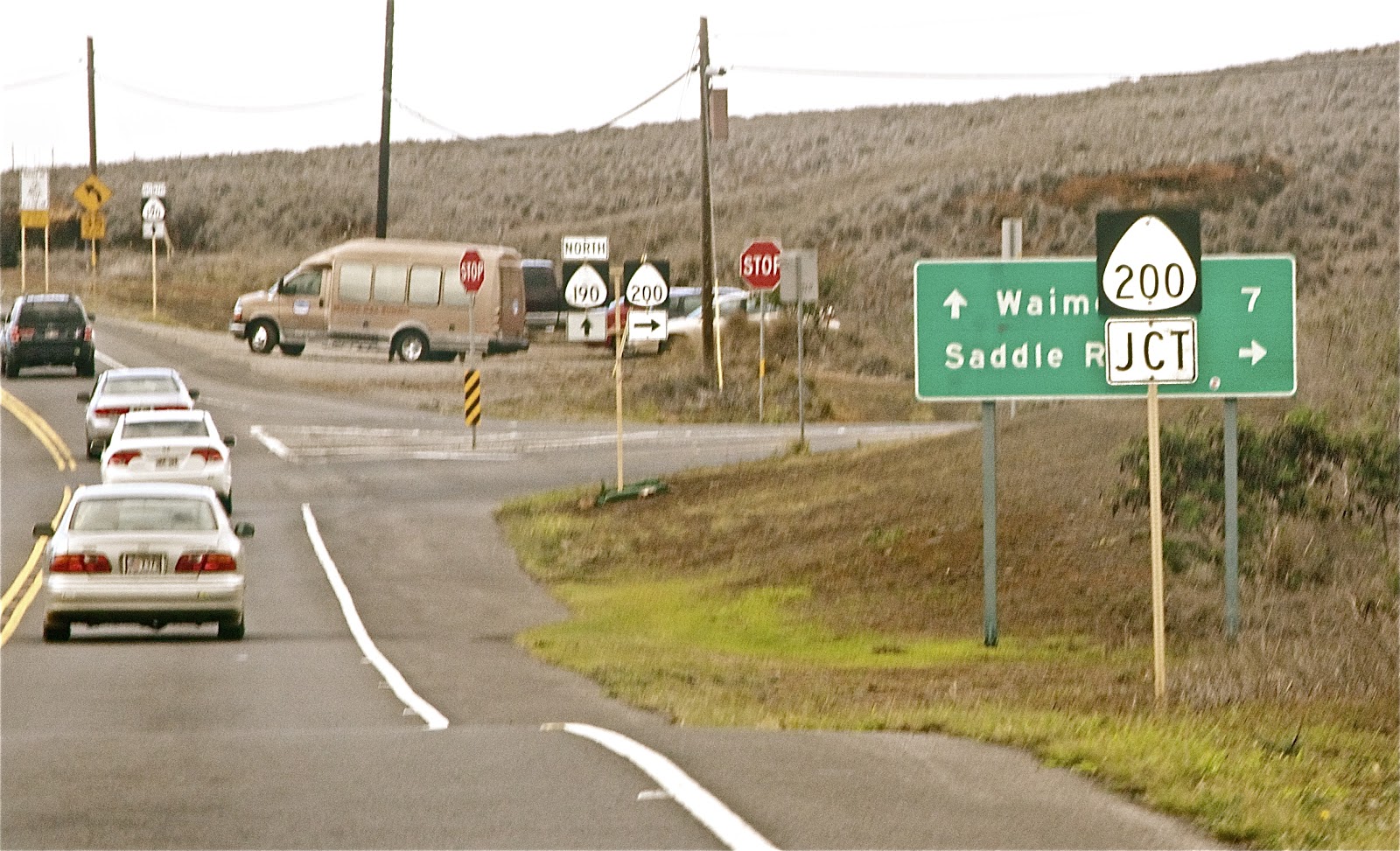
This final section of Saddle offers prime views of the Kohala Mountains, Hualalai and the leeward Coast. Saddle merges into Mamalahoa Highway (aka Hawaii Route 190 and Hawaii Belt Road). Travel North 7 miles to fine dining in Waimea, to the South for Kona Town or the luxury hotels of the Kohala Coast.
The once rugged path has been transformed into a lean, mean, driving machine thanks to the efforts of Senator Daniel Inouye. He knew Hawaii islands did not have resources and infrastructure enjoyed by our Mainland neighbors. He worked hard to provide for us. Mahalo nui loa, e Senator Inouye. Aloha kakou ia'oe.
Mahalo to Wikipedia for supplemental information
No comments:
Post a Comment